
Checklist of Online Vegetation and Plant Distribution Maps
World | Africa | Arctic | Asia | Central America & West Indies | Europe | Indian Ocean | North America | (Canada) (Mexico) (USA) | Pacific | South America | Other Sites | Acknowledgements
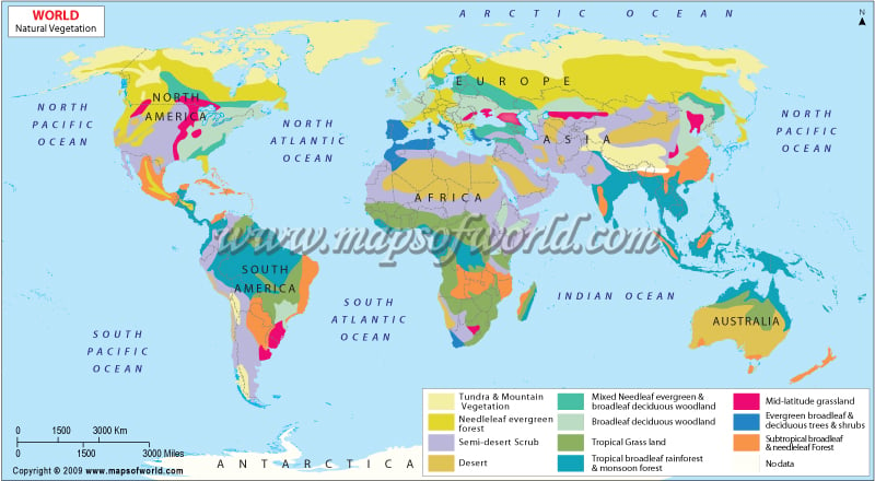
World
World
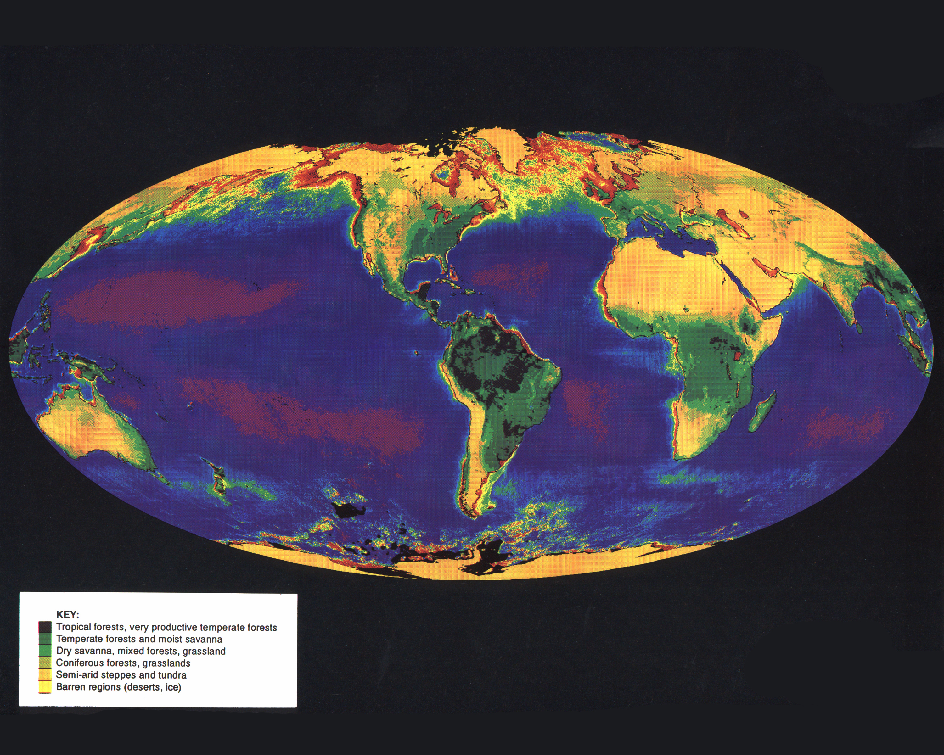
Bailey Ecoregions Map (Net Primary Productivity Project)
Drylands : Aridity Zones of the World (for 10 maps of World's drylands)
Global Atlas of Palaeovegetation Since the Last Glacial Maximum (Includes maps of Europe, Eurasia, Africa, Australasia, North America and South America / Quaternary Environments Network)
Terrestrial Ecoregions of the World (National Geographic, WWF)
Umrisse der Pflanzengeographie, 1838 (In: Dr. Heinrich Berghaus Physikalischer Atlas, 1849)
Die Vegetations-gebiete der Erde (In: Richard Andree's allgemeiner Handatlas in sechsundachtzig Karten mit erläuterndem Text, 1881)
World : Percent Vegetation Cover (Defries, et al., 1999, 2000)
World : Terrestrial Biomes, Terrestrial and Freshwater Biogeographic Realms, and Marine Biogeographic Realms (sensu Dasmann, 1974; Udvardy, 1975)
World -- Vegetation & Ocean Currents (In: Times Survey Atlas of the World, 1922)
World Wilderness Areas : Countries with the Most Wilderness (Sierra Club, World Bank, UNEP/GRID)
Eurasia
- Caucasus
Latin America
Middle East
Vegetation Map of the Middle East (Legibility problems)
Southern Hemisphere
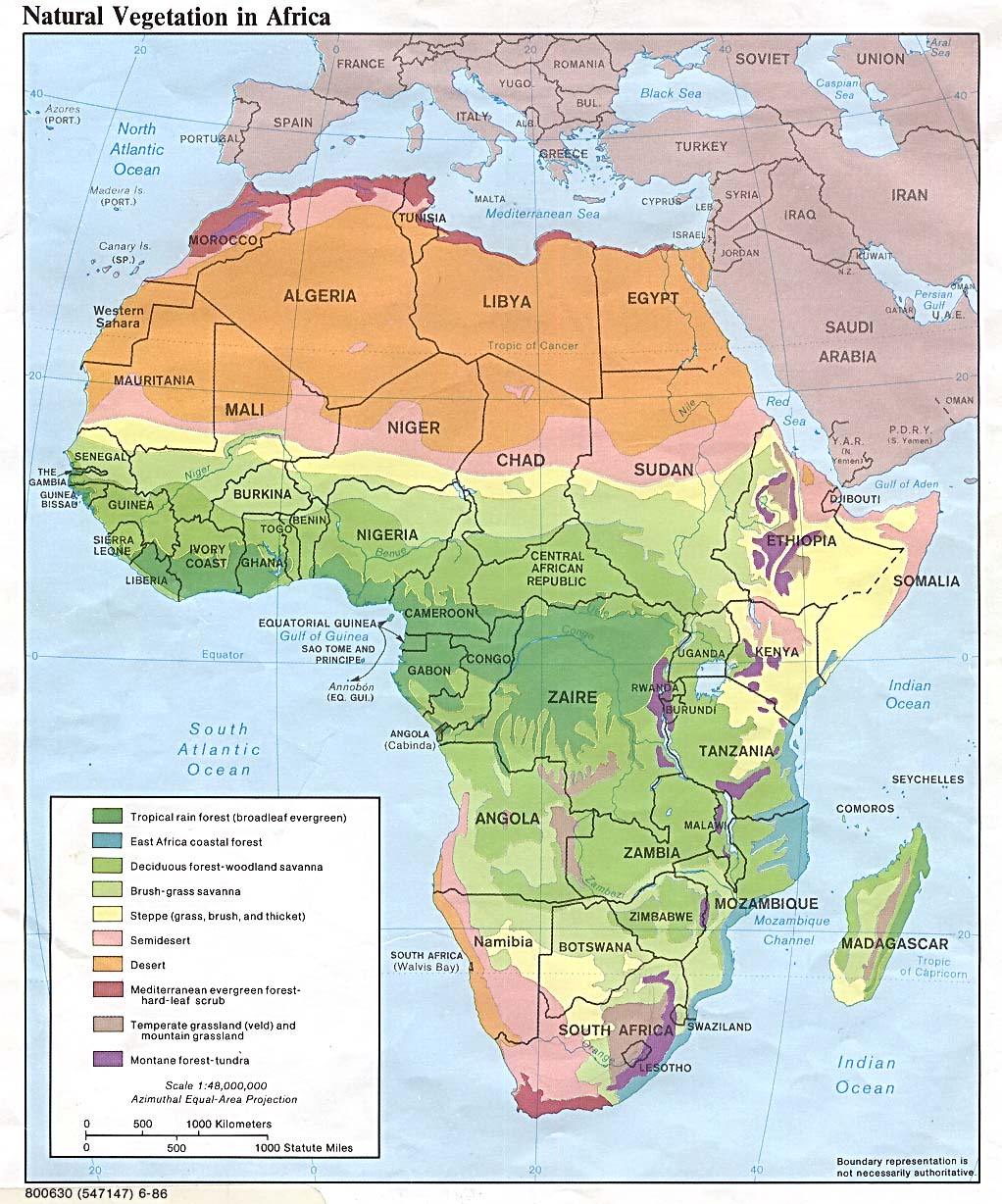
Africa
African Lowland Rain Forest (In Vegetation Patterns and Environmental Gradients in Benin / Aristide Cossi Adomou, p. 2)
Cloud Forest Sites in Africa (UNEP-WCMC)
Prevailing Vegetation (Inset on: Africa -- Political. In: Times Survey Atlas of the World, 1922)
Vegetation Map of Africa = Carte de Végétation de l'Afrique (3 sheets/feuilles: Southern Africa -- North-Western Africa -- North-Eastern Africa)
Africa, Central
Afrique Central Ouest, Afrique Central Est (In: Atlas des populations indigènes des forêts denses humides)
CARPE Mapper (Central African Regional Program for the Environment)
Africa, East
Africa, North
Africa, Southern
National Vegetation Map of Southern Africa Project (Maps covering South Africa, Lesotho, Swaziland; South African National Biodiversity Institute)
South Africa vegetation (Maps covering Baviaanskloof Mega-Reserve, South Africa and Nambia vegetation types, Mpumalanga vegetation, and Little Karoo)
Africa, West
Vegetation Map of West Africa Showing the Rain Forest Zone and Benin Indicating the Semi-deciduous Forest Sites Where Data Were Collected (In Vegetation Patterns and Environmental Gradients in Benin / Aristide Cossi Adomou, fig. 4.1)
Algeria
Angola
Benin
The Four Proposed Floristic Areas of Benin Based on Major Plant Community Patterns (In Vegetation Patterns and Environmental Gradients in Benin / Aristide Cossi Adomou, fig. 2.3)
Map of Benin Showing the Three Major Vegetation Zones According to WhiteL (1983) and the Locations of Protected Areas (In Vegetation Patterns and Environmental Gradients in Benin / Aristide Cossi Adomou, fig. 1.3)
Botswana
Burkina Faso
Cameroon
Central African Republic
Chad
Congo (Brazzaville)
Congo (Zaïre)
Côte d'Ivoire
Carte de la végétation de la Côte d'Ivoire (4 feuilles)
Ethiopia
Gabon
Ghana
Guinea
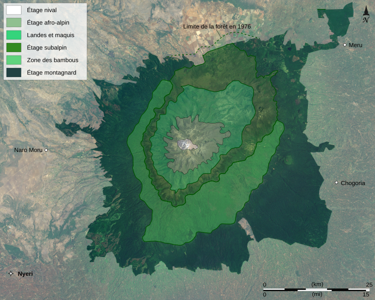
Kenya
Liberia
Libya
Madagascar
Malawi
Mauritania
Morocco
Mozambique
Namibia
Niger
Nigeria
Saint Helena
Sierra Leone
South Africa
![[Kalahari Desert]](http://web.archive.org/web/20060615104649/http://abbott-infotech.co.za/vegetation-map-mod-3.gif)
Sudan
Tanzania
Togo
Tunisia
Uganda
Victoria, Lake Region
![[Lake Victoria Region Forests]](http://web.archive.org/web/20070729043642/http://www.inweh.unu.edu/lvfo/images/victoria_forest.gif)
Zambezi Basin
Polar Regions
Svalbard
Arctic Svalbard Archipelago : Sphagnum (Bryophyta) in the Hornsund Area, Spitzbergen - S. riparium and S. quarrosum (Bryophyta) (The first documented record of Sphagnum riparium (Bryophyta): Sphagnaceae from Spitsbergen)
Asia (see also Eurasia)
Asia
Eastern Asia Temperate Forest and Protected Areas (Map 10 UNEP-WCMC)
Vegetation Index Map of Asia (1986, 1990, 1993)
Asia, Central
Asia, East
Mountains and Mountain Forests Far East (UNEP-WCMC)
Asia, South
Asia, Southeast
Cloud Forest Sites in South-east Asia (Covers also New Guinea, Australia and surrounding islands, UNEP-WCMC)
Geographical Distribution of Biomass Carbon in Tropical Southeast Asian Forests: A Database (Includes: Potential carbon densities in forests; Vegetation type; Ecofloristic zone classification; Actual carbon densities in forests)
Mangrove plant diversity in Southeast and East Asia (UNEP/GEF SCS)
Afghanistan
Armenia
Borneo
Bornéo Nord, Bornéo Sud (In: Atlas des populations indigènes des forêts denses humides)
Burma
Cambodia
Cambodia Atlas (Includes layers showing community forestry, seed source sites, terrestrial vegetation and landuse patterns, protected areas and forests, forest cover (various years), forest disturbance; by Royal Danish Embassy, Danish International Development Assistance)
China
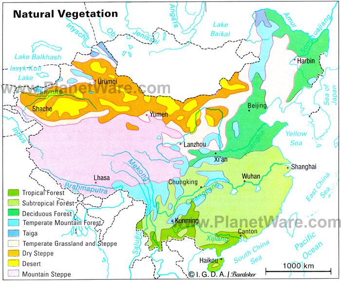
- Tibet
India
- Goa
- Nilgiri District
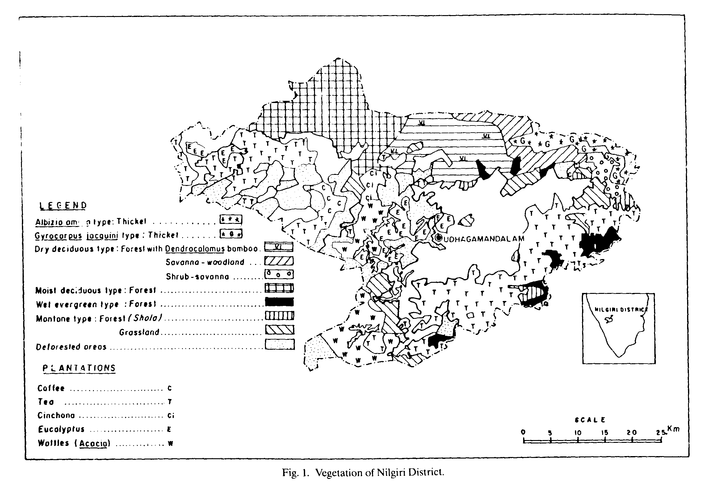
- India, South
- Maharashtra
- Western Ghats
Indonesia
Célèbes; Moluques et Seram (In: Atlas des populations indigènes des forêts denses humides)
- Irian Jaya
Nouvelle-Guinée Ouest, Nouvelle-Guinée Est = Irian Jaya; Papua New Guinea (In: Atlas des populations indigènes des forêts denses humides)
- Jambi Province
- Krakatoa
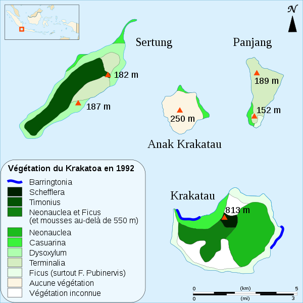
- Sumatra
Iraq
Israel
Japan
- Hokkaido
Kazakhstan
Korea
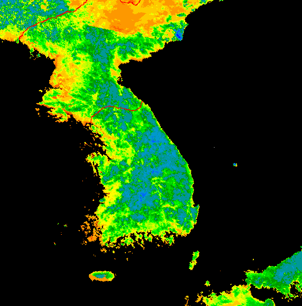
Malaysia
Malaisie peninsulaire (In: Atlas des populations indigènes des forêts denses humides)
Mekong River Valley
Mekong River Commission for Sustainable Development (Includes land use maps)
Mongolia
Philippines
Bio-Physical Influences on the Dupinga Watershed and Gabaldon Valley (In: Poffenberger, M. and McGean, B. (eds.) (1993). Upland Philippine Communities: Guardians of the Final Forest Frontiers)
Dupinga Watershed (In: Poffenberger, M. and McGean, B. (eds.) (1993). Upland Philippine Communities: Guardians of the Final Forest Frontiers)
Forest Cover in Upper Pulangi: 1987 (In: Poffenberger, M. and McGean, B. (eds.) (1993). Upland Philippine Communities: Guardians of the Final Forest Frontiers)
Historical Forest Maps of Dupinga Watershed (In: Poffenberger, M. and McGean, B. (eds.) (1993). Upland Philippine Communities: Guardians of the Final Forest Frontiers)
Major Wathersheds and Forest Cover of the Philippines 1987-1988 (In: Poffenberger, M. and McGean, B. (eds.) (1993). Upland Philippine Communities: Guardians of the Final Forest Frontiers)
Philippines (In: Atlas des populations indigènes des forêts denses humides)
Vegetation Map of the Dupinga Watershed (In: Poffenberger, M. and McGean, B. (eds.) (1993). Upland Philippine Communities: Guardians of the Final Forest Frontiers)
Sri Lanka
Distribution of the Principal Plant Communities in Sri Lanka Physiognomic Vegetation Map of Sri Lanka (Ceylon) (Journal of Biogeography, v. 2, no. 3, Sept. 1975)
Thailand
![Thailand : [Forests]](http://homepage.univie.ac.at/Christian.Puff/_images/Thailand_veg.jpg)
Vietnam
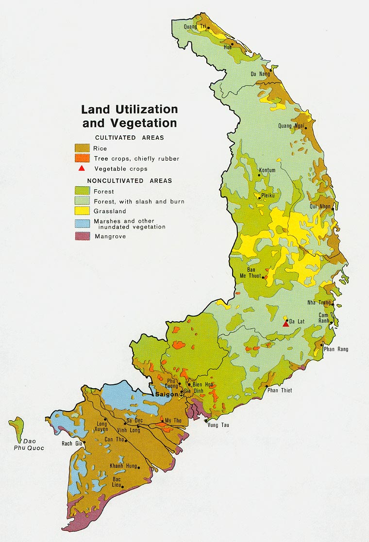